If our time traveller back in 1900 (see blog 1 in this section) had crossed the River Ouse at the Booth’s Ferry Bridge and moved into the south bank of the Humber region what would he/she have found? Firstly, unlike on the north bank he/she would have found the road system very similar to today except, of course, for the M180, roughly following the route of the A18, and the A15 Humber Bridge approach road (the former A 15 leading from Brigg to New Holland, the Hull ferry terminus). He/she would find an identical rail system apart from the marshaling yards and access lines to the port of Immingham.
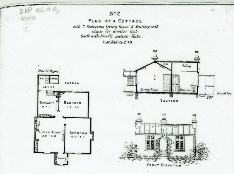
In the five parishes of Scunthorpe he/she would have found the grid-plan of bye-law housing streets behind Frodingham Road as seen today, the tenants, mostly having come to Scunthorpe to find work in the then three steelworks, a mix of people from across Britain but not the cultural diversity seen today. In the traditional village centres such as Crosby would be cottages built of the local limestone, a friable Lias stone set in heavy mortar and still found in Winterton, Winteringham, South Cave and Hotham. Some of the cottages would have been single-storey or ‘one-and-a-half’ storey, similar to the one seen above. The above illustration was copied from a British Parliamentary Paper (Vol. 10, Agriculture) for 1867/’68. At that time the issue of low-cost sanitary accommodation for farm workers was becoming high profile. Generally agricultural prosperity was high at that time and wealthier farmers could see a small return on building cottages for their more valuable workers (but certainly not all workers), this ceased to be the case during the Agricultural Depression of the late 19th century.
Travelling east our 1900 explorer could visit Barton on Humber and would have seen the market town surrounded closely by fields, these now all being covered by housing estates, the Humber Bridge since 1981 making bank to bank commuting relatively straightforward.
(to be continued)