Walking west along the Humber flood bank from Crabley Farm on the left is a large linear reedbed which, along with Whitton Sand and Faxfleet Ness, form sections of one of the Humber Estuary’s nature reserves, characterised here by extensive reedbeds. The Estuary side of the reedbed is determined by the depth of water in that part of the Estuary as reeds cannot survive in water deeper than about a meter for any length of time, which explains why water bodies that gradually become more shallow through humus deposition become more overtaken by reeds.
Looping between Market Weighton Lock and Crabley Farm is a drain called Broomfleet Hope. This, almost certainly, marks the once Humber coastline in this area, before reclamation of the intervening land; a situation mirroring that of Cherry Cobb Sands and Sunk Island. The linear village of Broomfleet, just inland of Broomfleet Hope, did not figure in the Domesday Survey but its ancestral names have been recorded since the 12th century. The Place Name Society records its etymology as initially referring to ‘Brungar’s stretch of the Humber Bank’ but the suffix ‘fleet’ suggests more. As with Fleetgate, Barton on Humber for example, ‘fleet’ suggests a port, or at least, an inlet used by early boats. However, the 19th century church and 18th century farmhouses and cottages do not provide evidence of earlier times. Just off the coast Whitton Sand, a huge colonised mudflat mostly of reedbed and managed by English Nature, has between it and the Humber Bank an open water channel; this similar to the channel allowing access to Patrington Haven still in Tudor times.
The low-lying, level land inland of the Humber bank in this area is the south-eastern portion of Wallingfen, it, in turn, the south-eastern portion of the Vale of York.
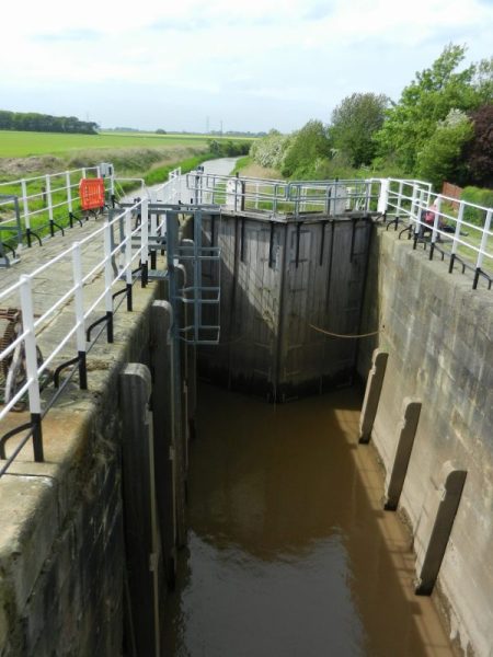
The photo above shows the lock part of the sluice at the mouth of the Market Weighton Canal, between Broomfleet and Faxfleet (see later).
(to be continued)